The highest point on the Île de Ré is called the Peu des Aumonts and rises to an elevation of 19 meters. It’s an almost symbolic height on an island known for its flat terrain, nestled among salt marshes, low-lying vineyards, and long beaches. A must-see during your vacation at our campsite on Île de Ré.
Key Points
- The highest point on Île de Ré is Le Peu des Aumonts, at an elevation of 19 meters.
- It is located at the junction of the towns of Bois-Plage-en-Ré, Sainte-Marie-de-Ré, and La Flotte, in the wooded area of Les Évières.
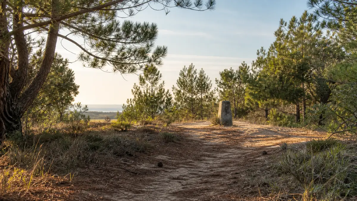
- A small concrete obelisk marks the summit, nestled among the dunes and the forest.
- The Baleines Lighthouse towers over the island at a height of 57 meters, but it is a man-made structure, not a natural landform.
Le Peu des Aumonts, a peak at an elevation of 19 meters
Le Peu des Aumonts is the official highest point onthe Île de Ré, with an elevation of about 19 meters above sea level.
This peak sits atop a former dune stabilized by vegetation, now covered by the Bois-Plage national forest. It was once known as Hauts-Monts, before becoming Peu des Aumonts. The word “Peu” comes from the regional term “Puy,” itself derived from the Latin “podium,” which refers to a height or an elevated place. The same root can be found in neighboring place names such as Peu Poiroux and Les Peux Hauts: local memory had already preserved the memory of the island’s most prominent landforms, however modest they might be.
Where exactly is the highest point on Île de Ré?
The summit straddles three municipalities—Le Bois-Plage-en-Ré, Sainte-Marie-de-Ré, and La Flotte-en-Ré—within the Évières Nature Reserve.
This location partly explains its seclusion. Hidden among the pine and holm oak trees, the Peu des Aumonts is unlike any other peak in the usual sense of the word: no unobstructed view, no orientation table, no crowds. It’s worth the effort precisely because it’s hidden away, which makes it an intriguing destination for a hike rather than a typical tourist spot.
How can I get to Peu des Aumonts on foot or by bike?
The easiest way to get there is to follow the bike path along the RD201 between Sainte-Marie-de-Ré and Le Bois-Plage-en-Ré, before turning toward the Hameau of Les Évières and then onto Chemin du Peu des Aumonts.
At the summit, a small concrete obelisk marks the exact spot. According to local tradition, hikers leave a pinecone there as a symbolic trophy after “conquering” the summit. The trail is well-suited for a bike ride from our campsite, along shaded and generally flat paths.
A tip from the campsite staff: We often suggest that families staying at the campsite combine this stop with a picnic in the Bois-Plage forest before biking to the nearby beaches.
The Baleines Lighthouse, the island’s premier vantage point
For a truly panoramic view, you should head to the Baleines Lighthouse in Saint-Clément-des-Baleines. Its lantern stands 57 meters high, for a total elevation of 59.39 meters above high tide.
The lighthouse is not included in the calculation of the highest natural point because it is a man-made structure. It remains, by far, the best viewpoint on Île de Ré: its steps lead to a 360° view of the ocean, the rocky headlands, and, on a clear day, the Vendée coast.
The Île de Ré doesn’t rely on high elevations to charm visitors. Its unassuming terrain, salt marshes, and impromptu viewpoints—whether from a lighthouse or a dune—tell a different story of the landscape, one closer to the water than to the sky. To continue exploring Île de Ré, head to the salt marshes, the Vauban fortifications, or the villages by bike!